Boreal

Zemgale Region, LV
Zemgale, covering 17% of Latvia, relies on groundwater for drinking and dense rivers for biodiversity and recreation. However, intensive agriculture, covering 40% of the region, has strained biodiversity, water quality, and management. As well the region is one of the most threatened areas in terms of flooding of the territory due to the flat terrain.

Introduction

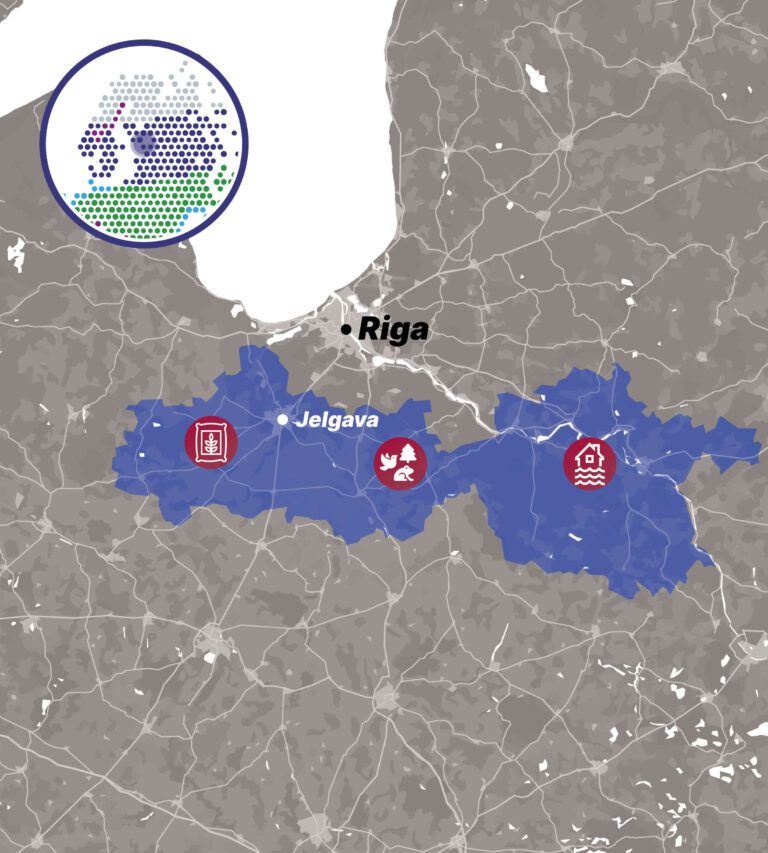
Zemgale Region is in the central part of Latvia in central part of the Zemgale Plain. Cities occupy 6% of the total territory of Zemgale Region. Zemgale is crossed by 2 major Latvian rivers: Daugava and Lielupe. Stocks of water resources are sufficient for economic activity and human consumption. The drinking water supply is ensured by a groundwater supply source. Lowland landscape in Zemgale Region is characterized by a flat terrain and a dense river network providing ecological corridors essential for biodiversity and recreational opportunities for people.  

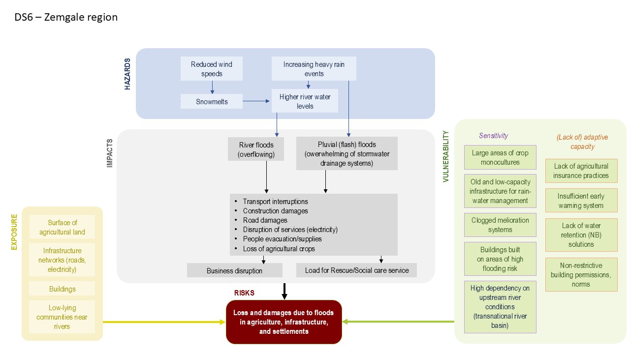
At the same time, thanks to its fertile soils, this area has developed into an intensive agriculture land – the large-scale farming covers 40% of the area. This has led to a severe decrease in biodiversity as well as pollution of water bodies, increasing flood risks and other environmental problems. Agricultural activities are well developed and focus on the cultivation of crops. 

During the last decade, the area of croplands has increased while meadows and pastures have been reduced putting pressure on grassland habitats. According to the prognosis for development of agriculture sector by 2050, these trends will be maintained and coupled with increased quantity of fertilisers utilised in line with intensification of agriculture which in turn has resulted in homogenisation of fields (continuous arable land fields larger than 30 ha) and biodiversity loss.  

The region is characterised by high flooding risk potential including flooding from snowmelts, high precipitation and hydrotechnical infrastructure. In case of flood events, the flooding risks are associated with fast and high rise in water level thus causing risks to society, settlements, and infrastructure. There is a need to assess Zemgale Plain and run an update of the civil protection aspects.  

Solutions

Fill out the survey below

1
2
3
4
5
6
7
8
Last Page

Some extreme weather events are becoming increasingly frequent – for example, heatwaves and prolonged droughts, which in some areas may alternate with unusually intense and rapid rainfall and flooding for this region. Alongside efforts to mitigate climate change, it is essential to plan and implement timely actions to adapt to the economic, social, and environmental impacts of climate change in the boreal Zemgale region. 

We care about your opinion on the impacts of climate change and the most suitable and regionally appropriate adaptation measures. Therefore, we invite you to complete the survey and select the two most important options for each question! 

Which two climate impacts do you consider the most significant? 

Which two of the following adaptation measures to storms do you consider the most important? 

Which two of the following adaptation measures to rain-induced flooding do you consider the most important? 

Which two of the proposed flood adaptation measures (for river floods) do you consider the most important?

Which two of the proposed adaptation measures to temperature changes do you consider the most important?

Which two of the proposed adaptation measures to drought do you consider the most important?

Which two awareness-raising measures on climate change adaptation do you consider the most effective? 

Adaptation Pathways

Impact chains (IC)

Due to its flat terrain, Zemgale region is characterised by high flooding risk potential. The flooding risks are associated to fast and high rise in water level in rivers from snowmelts due to fast increase of temperatures in winter/spring period. Floods in rivers most often occur in the spring, especially because of ice jams. Floodings pose a risk to agriculture, settlements, infrastructure and society.

The overflowing of Daugava River in Spring 2013 in Plavinas town caused serous damage: 80 residential houses, several historical and public buildings, streets, private companies, the municipal sewage system were flooded – the total estimated loss for the Plavinas municipality accounted for more than 220 000 EUR. Spring floods in 2017 caused damage of 100 000 EUR to the town municipality. In the Lielupe River basin, the most threatened place has become the Jelgava State City, which suffers from floods caused by ice jams almost every year. Spring floods in 2010 caused ca. 100 000 EUR losses to the Jelgava State City and 133 000 EUR to the Jelgava County municipality.

Floods are caused also by heavy rain events overwhelming drainage system in rural territories and stormwater drainage system in urban areas. In October 2014, Zemgale region was hit by long-lasting rains and the water level in the small rivers rose significantly. Overflow of rivers along the deficiencies in the management of drainage systems caused flooding of some residential areas and creating damage to infrastructure. Heavy storm rainfall at the end of July 2024 caused severe flooding in Zemgale region, particularly in Jelgava State City. It has been assessed that ca. 3.6 million EUR are needed for Jelgava Municipality to repair the damage caused for infrastructure, buildings, etc.

In the agriculture sector, floods can pose damage to crops and cause flood-induced crop losses. The severity of flood-related damage largely depends on effectivity of drainage systems. Old, clogged drainage systems increase the vulnerability of the area. The vulnerability of the agriculture sector increases along with the reluctance of farmers to purchase insurance against flood risks, lack of application of water retention solutions, including nature-based solutions like constructed wetlands. This causes a poor adaptation capacity of the agricultural sector to cope with and increasing risk of flooding.

In urban areas, insufficient capacity of rainwater management system increases the flooding risk of settlements in case of heavy precipitation. Buildings constructed in flood prone areas e.g., nearby streams or rivers are particularly vulnerable. Insufficient early warning system in case of river floods and flash floods caused by heavy rain reduces the level of preparedness of all sectors in the region.

Pathway Map

Explore other Knowledge Boosters

Mountains

Arctic

Mediterranean

Coastal

Continental

Atlantic